A WINTER STORM WARNING continues for the Elkhorn and Boulder Mountains, southern Rocky Mountain Front, Ruby Mountains, and Beaverhead Mountains through noon today.
A WINTER STORM WARNING continues for the Little Belt and Highwood, Snowy, Judith, Gallatin, Madison, Centennial, Big Belt, Bridger, and Castle Mountains through 6 PM this evening.
A WINTER STORM WARNING continues for the Crazy Mountains through midnight today.
A WINTER STORM WARNING continues for the Absaroka and Beartooth Mountains through midnight today.
A WINTER STORM WARNING continues for the Pryor and Bighorn Mountains through 6 AM Friday morning.
A WINTER STORM WARNING continues for Homestake Pass, MacDonald Pass, and Georgetown Lake through noon today.
A FLOOD WATCH continues for the Little Belt and Highwood Mountains through Friday morning.
A WINTER WEATHER ADVISORY continues for the I-90 corridor between Bozeman and Whitehall, the Madison and Beaverhead River Valleys through 6 PM this evening.
A WINTER WEATHER ADVISORY continues for the Gates of the Mountains and Scratchgravel Hills from midnight tonight through noon this evening.
A WINTER WEATHER ADVISORY continues for the Bighorn Mountains through 6 PM this evening.
——————————————————————————————————————————
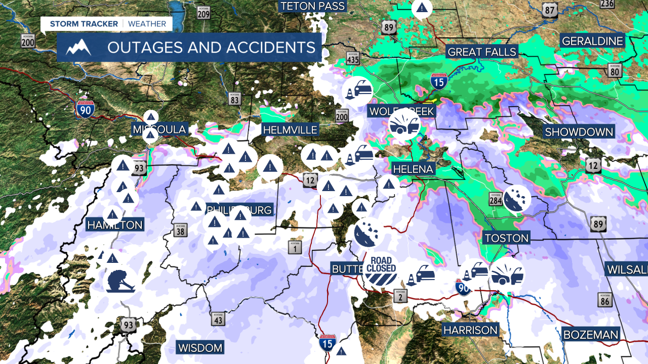
Heavy wet snow continues to fall across much of the higher elevations of southwest Montana, impacting travel and causing power outages across the region.

Luckily for the Helena area, we were mostly spared from the snow. A few power outages and downed power likes were reported in the Boulder Mountains throughout the morning hours. Most power outages are concentrated in Missoula, Ravalli. Granite, and Powell counties.
According to poweroutage.us, between 2,000 and 5,000 customers have been without power through the course of this morning. Crews are out on the scene working diligently to restore power.
There have been several accident and and disabled vehicle reports this morning as well. Incidents were reported on I-15 near Wolf Creek, I-15 northbound near Boulder, MacDonald Pass, Rogers Pass, and I-90 near Homestead Pass. I-90 eastbound is currently closed due to multiple accidents. Snow chains are required for most towing units through mountain passes this morning.

The rain and snow will continue to push southeastward through the state today, giving the potential for more traffic and power issues.
Helena should be in the clear between 10-12 AM. The sun will come out this afternoon, allowing for the development of some thunderstorms in the remaining instability that will last throughout tonight. Highs will be in the mid 50s.

Tomorrow there will be some isolated showers and storms around, but most places will stay dry. Highs will be in the 60s.
Another low pressure system makes its way into the state Saturday that will give some rain, but not nearly as much as we have experienced over the pass few days.

Sunday will be mostly dry and warm, with only some remaining showers in the morning. We will be close to 70°.
Next week is trending dry and warm on Monday and Tuesday, with temperatures in the upper 70s and low 80s. A small disturbance will bring thunderstorms to much of the state on Wednesday.
Helena Temperature Records Today:
High: N/A
Low: N/A
AVG: 68/43
Great Falls Temperature Records Today:
High: N/A
Low: N/A
AVG: 66/40
Have a great Thursday!
Joey Biancone
Meteorologist
Facebook: Meteorologist Joey Biancone
Instagram: joeybianconewx
Email: joey.biancone@ktvh.com


