


Wintry weather entered the state Friday morning and will stick around until early next week. We got a coating of snow in Helena before sunrise. More is on the way throughout the day and into Saturday morning.
(Watch a timelapse of the Snow Moon set over the mountains west of Helena yesterday morning)
Widespread 1-3" totals are expected for many lower elevations through noon Saturday. Instances of 4-6" are likely in the mountains. The heaviest snowfall rates will occur this afternoon into this evening, mainly after 3 PM.
A change we have made to the forecast since yesterday is lowering highs for this weekend in Helena. It will be very difficult to get rid of the cold air in place. Plus we will have more spilling into the valley. Highs will not reach above the low teens and single digits.
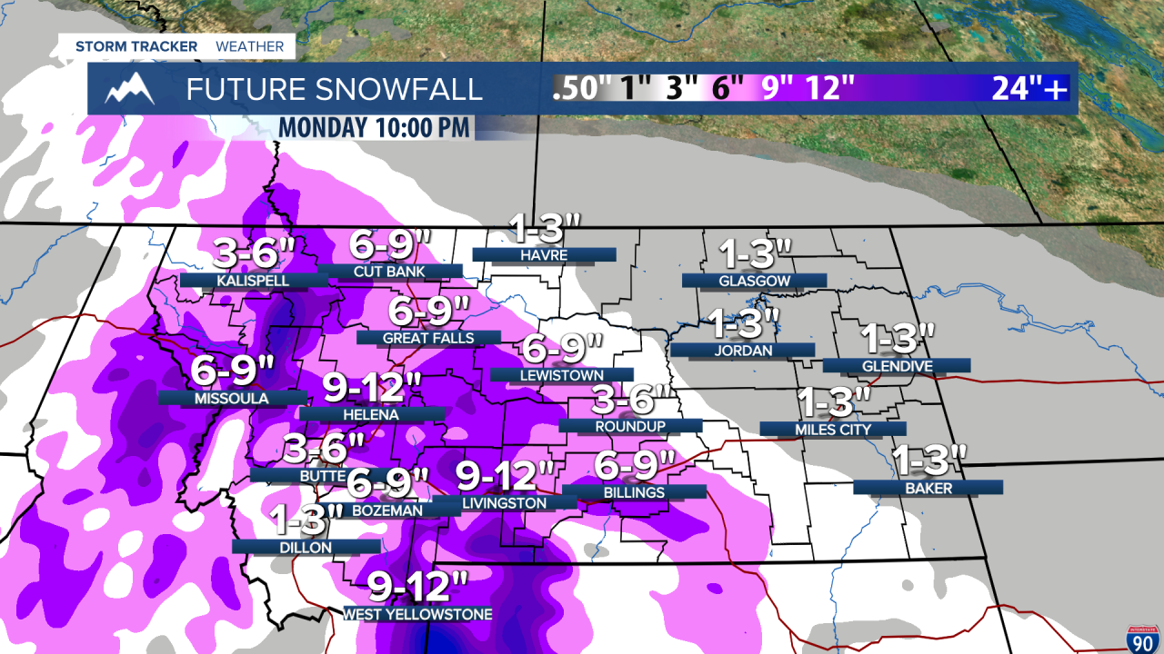
A more significant snowstorm enters the state during the day on Sunday. We are likely looking at heavier snowfall for the western half of the state. A line of consistent snow will stretch from the Kalispell area towards the southeast through all of Sunday and into Presidents Day. This will make holiday weekend travel treacherous.
Another blast of significant arctic air is becoming more likely to begin next week. lows in single digits and 20s below zero will be common, especially along the Hi-Line.
Warmer weather is on the way, however. Towards the middle and end of next week, highs will reach above the freezing point for the first time since February 1st.
——————————————————————————————————————————
Weather Alerts:
A COLD WEATHER ADVISORY continues for Daniels, Northern Valley, Sheridan, and Roosevelt Counties until noon Friday
A WINTER WEATHER ADVISORY has been issued for the Big Belt, Bridger and Castle Mountains, Gallatin Valley, and Gallatin and Madison County Mountains and Centennial Mountains from 3 PM Friday until 10 AM Saturday
A WINTER WEATHER ADVISORY has been issued for western and central Chouteau County, Bears Paw Mountains and Southern Blaine, Cascade County below 5000ft, Judith Basin County and Judith Gap, Fergus County below 4500ft, Little Belt and Highwood Mountains, and the Meagher County Valleys from 3 PM Friday until 10 AM Saturday
A WINTER WEATHER ADVISORY has been issued for the Missoula and Bitterroot Valley from 5 PM Friday until 11 AM Saturday
A WINTER WEATHER ADVISORY has been issued for the Mission Valley, Highway 93 Eureka to Whitefish, Bad Rock Canyon, Polson, Highway 83 Bigfork to Swan Lake, Highway 83 Seeley Lake to Condon, Polebridge, Highway 37 Eureka to Libby, Highway 200 Bonner to Greenough, Highway 56 Bull Lake Road, Highway 2 Kalispell to Libby, Flathead Lake, I-90 East Missoula to Bearmouth, Marias Pass, Essex, and Flathead Valley from 11 PM Friday until 11 AM Saturday
A WINTER WEATHER ADVISORY has been issued for Evaro Hill, I-90 Lookout Pass to Haugan, Highway 93 Sula to Lost Trail Pass, Lolo Pass, Highway 200 Thompson Falls to Plains, and Highway 200 Trout Creek to Heron from 5 PM Friday until 11 AM Saturday
A WINTER WEATHER ADVISORY has been issued for the Flathead Valley, Flathead Lake, Highway 200 Bonner to Greenough, Highway 93 Eureka to Whitefish, Highway 83 Seeley Lake to Condon, Mission Valley, Highway 83 Bigfork to Swan Lake, I-90 East Missoula to Bearmouth, Marias Pass, Highway 56 Bull Lake Road, Polebridge, Highway 37 Eureka to Libby, Polson, Highway 2 Kalispell to Libby, Essex, and Bad Rock Canyon from 5 PM Friday until 11 AM Saturday
A WINTER WEATHER ADVISORY has been issued for Lolo Pass, I-90 Lookout Pass to Haugan, Highway 200 Thompson Falls to Plains, Evaro Hill, Highway 93 Sula to Lost Trail Pass, and Highway 200 Trout Creek to Heron from 5 PM Friday until 11 AM Saturday
A FLOOD ADVISORY continues for Madison County until noon Friday
——————————————————————————————————————————
Helena Temperature Records Today:
High: 61 (2015)
Low: -27 (1936)
AVG: 37/17
Great Falls Temperature Records Today:
High: 65 (1921)
Low: -35 (1936)
AVG: 37/15
Have a great Valentine's Day!
Joey Biancone
Meteorologist
Facebook: Meteorologist Joey Biancone
Instagram: joeybianconewx
Email: joey.biancone@ktvh.com


