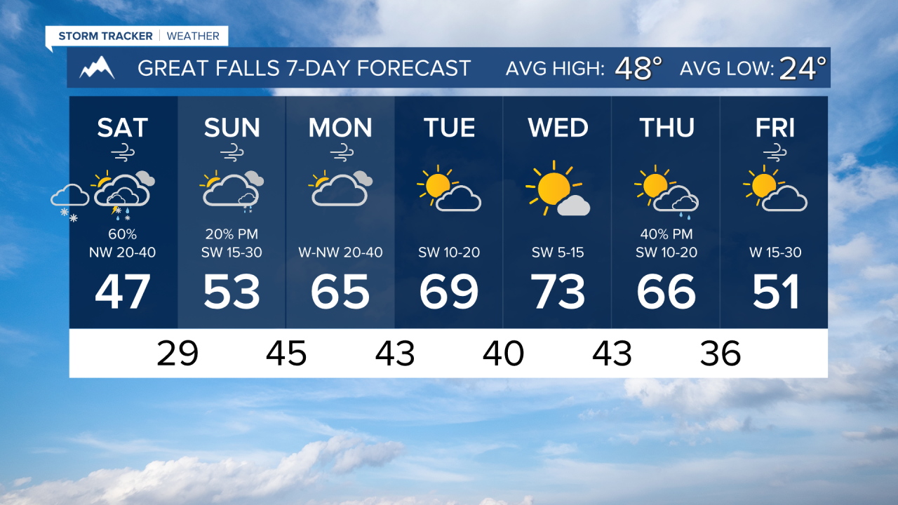
Moderate to heavy snowfall will come in early Saturday morning along a cold front. We will see snow in lower elevations, but aside from the valleys of southwestern Montana, accumulation will be light. Most of the snowfall will be concentrated in the mountains, especially near the northern Rocky Mountains Front and Glacier, where over a foot can fall. Additionally, strong winds can cause blowing snow issues.

Speaking of the strong winds, multiple wind alerts have been put in place for western Montana for widespread 50-60 MPH gusts. This includes the Helena Valley. You can expect the gustiest of the wind to come through around midday Saturday.
Another smaller disturbance comes in Sunday into Monday. Light snow is possible, but this will mainly be focused on the wind once again. Another high wind event is likely, especially in eastern Montana. It is not out of the question that we could see increased fire danger with this.
Aside from a few showers Sunday into Monday, next week is looking dry up until another cold front comes in sometime late in the week. The forecast is still on track for temperatures to push into the upper 60s and 70s throughout the week.
——————————————————————————————————————————
WEATHER ALERTS:
A HIGH WIND WATCH has been issued for Judith Basin County and Judith Gap; Fergus County below 4500ft; Upper Blackfoot and MacDonald Pass; Snowy and Judith Mountains; Helena Valley; Big Belt, Bridger and Castle Mountains; Meagher County Valleys; Elkhorn and Boulder Mountains; Canyon Ferry Area; Missouri Headwaters; Gallatin Valley from Saturday morning until Saturday afternoon
A HIGH WIND WARNING has been issued for Judith Gap, Southern Wheatland, Melville Foothills, and Northern Sweet Grass from 3 AM Saturday until 6 PM Saturday
A WIND ADVISORY has been issued for the Beartooth Foothills and Livingston Area from 9 PM Friday until 9 AM Saturday
A WIND ADVISORY has been issued for the Butte/Blackfoot Region from 10 AM Saturday until 6 PM Saturday
A WINTER STORM WARNING continues for I-90 Lookout Pass to Haugan until noon Saturday
A WINTER WEATHER ADVISORY continues for the West Glacier Region and Bitterroot/Sapphire Mountains until noon Saturday
A WINTER WEATHER ADVISORY continues for the Continental Divide along the Rocky Mountain Front until midnight Saturday
A WINTER WEATHER ADVISORY has been issued for the Mountains of Southwestern Montana south of Interstate 90, and The Madison and Beaverhead River Valleys from midnight Friday until noon Saturday
A WINTER WEATHER ADVISORY has been issued for I-90 East Missoula to Bearmouth, Highway 83 Seeley Lake to Condon, and Highway 200 Bonner to Greenough from midnight Friday until noon Saturday
A WINTER WEATHER ADVISORY has been issued for Butte, Homestake Pass, MacDonald Pass, Highway 12 Garrison to Elliston, and Georgetown Lake from midnight Friday until noon Saturday
A WINTER WEATHER ADVISORY has been issued for the Little Belt and Highwood Mountains from midnight Friday until midnight Saturday
An AVALANCHE WATCH continues for the Selkirk, West and East Cabinet, and Bitterroot Mountains - Silver Valley above 4,000 feet until 6 AM Saturday
——————————————————————————————————————————
Helena Temperature Records Today:
High: 73 (1928)
Low: -11 (1913)
AVG: 50/26
Great Falls Temperature Records Today:
High: 74 (1928)
Low: -16 (2002)
AVG: 48/24
Have a great weekend
Joey Biancone
Meteorologist